
Weather Aware: Tornado warnings issued in Charlotte area ()
Multiple tornado warnings were issued Thursday as a line of storms swept over the Charlotte area ahead of Hurricane Helene.
CHARLOTTE, N.C. — Multiple tornado warnings were issued in the Charlotte area Thursday morning ahead of Hurricane Helene as a line of storms brought heavy rain and gusty winds to the Carolinas.
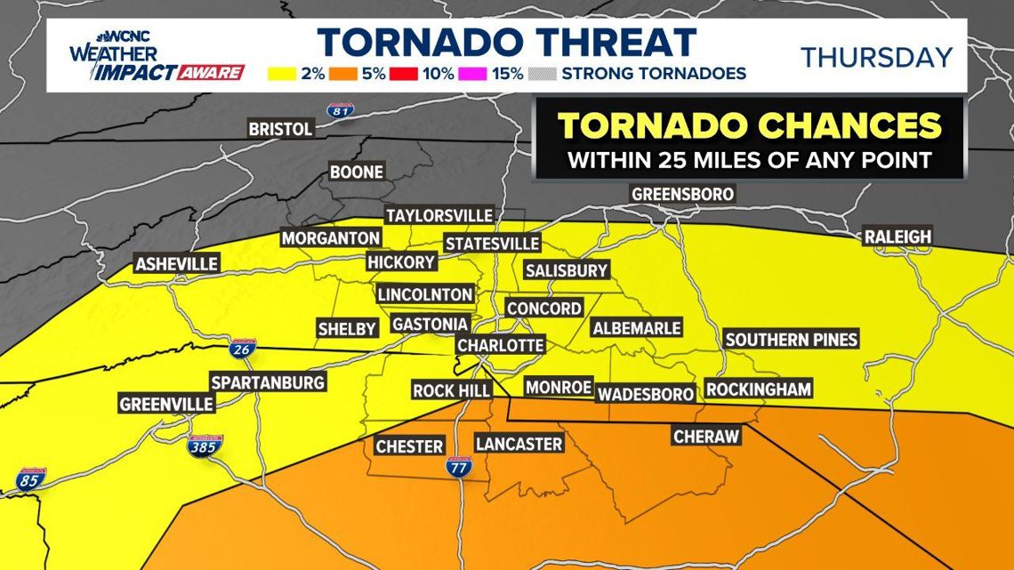
Warnings were issued in Alexander, Catawba, Gaston, Iredell and Mecklenburg counties during the outbreak. No tornadoes have been confirmed by the National Weather Service at this time. Meteorologist Chris Mulcahy said the Charlotte area will be at risk for spin-up tornadoes because it’s on the “dirty side” of the hurricane.
Many of these tornadoes could be rain-wrapped, meaning they wouldn’t be visible in all locations.

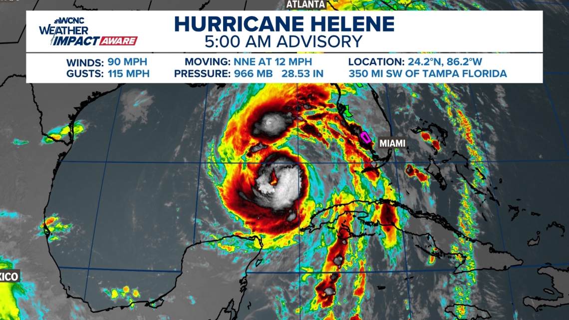
Hurricane Helene continues to strengthen over the warm Gulf of Mexico, as it was upgraded to a Category 2 hurricane on Thursday morning, the National Hurricane Center said.
Helene is now a Category 2 hurricane with sustained 100 mph winds. The NHC reported gusts up to 115 mph as the storm entered the Gulf of Mexico with “significant additional strengthening” likely. This process is known as rapid intensification and could lead to catastrophic wind, storm surge and flooding on Florida’s Gulf Coast as Helene makes landfall.
LIVE RADAR: Tracking Helene, impacts on the Carolinas
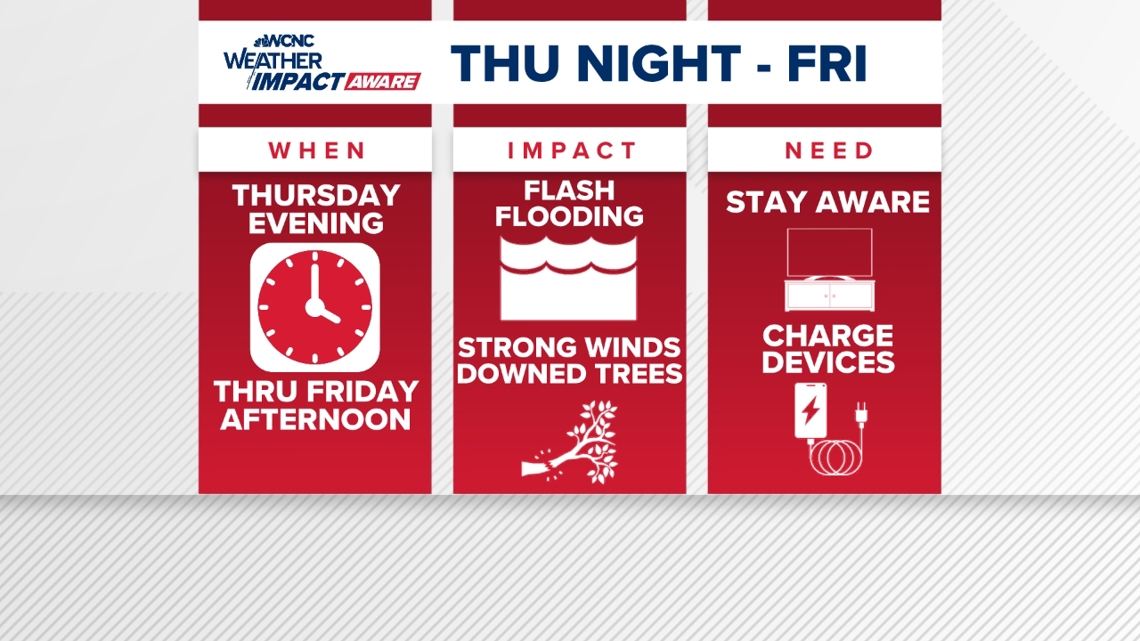
A cold front brought heavy rain and severe weather to the Charlotte area on Wednesday and the Carolinas are bracing for the impacts of Hurricane Helene starting Thursday evening.
Tropical storm watches and warnings are in place, including portions of our viewing area. A Tropical Storm Warning is in effect for Mecklenburg, Union, York, Chester, Gaston, Lincoln, Catawba, Cleveland, Burke, Caldwell and Avery counties. Impacted cities and towns include Banner Elk, Shelby, Lenoir, Morganton, Hickory, Newton, Gastonia, Charlotte, Rock Hill, Fort Mill, Chester, Lincolnton, Monroe, Huntersville, Matthews, and Cheraw.
A Tropical Storm Warning is issued with tropical-storm-force conditions are expected within a 36-hour period. In this case, our conditions will deteriorate Thursday afternoon and last through at least midday Friday.
Additionally, a Flood Watch is in place for Alexander, Catawba, Cleveland, Lincoln, Avery, Burke, Caldwell, Ashe, and Watauga counties. This is due to significant flooding possible for the mountains and foothills especially, where there’s potential for 5-10 inches of rain between now and Friday afternoon.

Closer to the Charlotte area, rainfall totals will range from 3-6 inches west of I-77 and around 2-4 inches east of the interstate.
On top of the wind and rain, the Carolinas are expected to be in the right-front quadrant of Helene, often referred to as the “dirty side”. This will lead to a higher-than-average risk of quick spin-up tornadoes. Tropical tornadoes are often very weak but they can still produce impacts.
When will Charlotte see impacts?
Impacts begin across the Carolinas Thursday afternoon and evening, becoming more intense through the overnight hours. High winds and heavy rain will last through at least midday Friday before conditions slowly improve throughout the day.
As of 8 a.m. Thursday, Helene is moving through the southern Gulf of Mexico with 100 mph winds. The storm is located about 320 miles southwest of Tampa, Florida, and is moving north-northeast at 12 mph. Helene will continue to move through extremely warm Gulf waters where it may experience more rapid intensification.

The forecast cone for Helene remains largely unchanged from previous models. Once the storm system moves into the Gulf of Mexico on Wednesday, it is expected to rapidly become a hurricane. Landfall is becoming likely in the Big Bend area of Florida Thursday night, at which point the storm is forecast to be a Category 3 major hurricane.
What impacts to expect
Rainfall totals near ten inches in the mountains and foothills are possible with half of that across most of the Charlotte area. On top of rainfall, gusty winds of tropical-storm force (above 40 mph) are likely to cause trees to fall and scattered power outages across the region.
Panovich said we should see better weather ahead for the weekend, as the wind and rain will move out fairly quickly.
What you need to know to stay safe
In the event of a severe storm, stay Weather Aware by:
- Seeking shelters indoors away from lightning and gusty winds
- Watching for flooded creeks and streams
- If you encounter a flooded roadway: turn around, don’t drown
- Monitoring radar for quick-moving thunderstorms that could disrupt outdoor plans
#Weather #Aware #Tornado #warnings #issued #Charlotte #area
1727360781, weather-aware-tornado-warnings-issued-in-charlotte-area